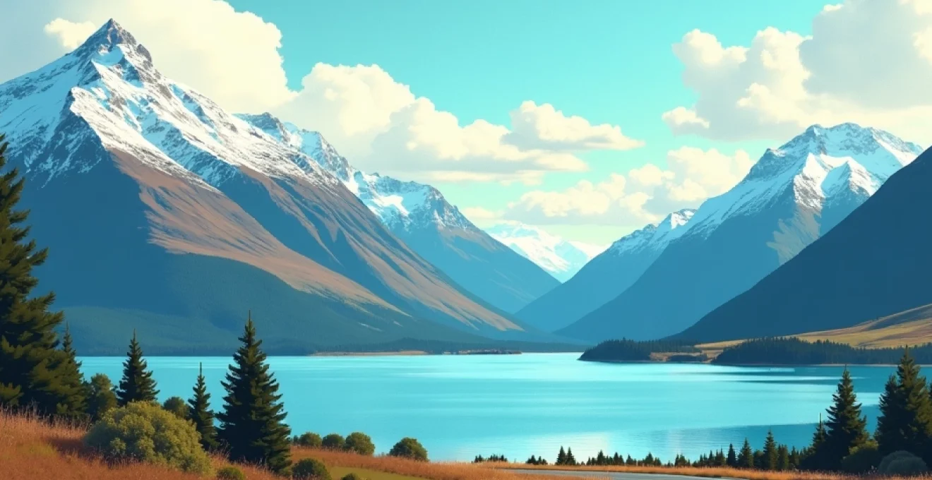
New Zealand’s South Island stands as one of the world’s most spectacular driving destinations, offering an unparalleled collection of scenic routes that traverse dramatic landscapes from snow-capped alpine peaks to rugged coastal fjords. With over 150,000 square kilometres of diverse terrain, the island presents motorists with opportunities to experience glacial valleys, pristine lakes, ancient rainforests, and volcanic formations all within a single journey. The infrastructure supporting these scenic drives has evolved significantly over recent decades, with modern engineering marvels like the Homer Tunnel and Haast Pass providing access to previously unreachable wilderness areas. Whether you’re seeking the adrenaline rush of navigating the Crown Range Road’s serpentine curves or the meditative experience of cruising through Canterbury’s golden tussock grasslands, the South Island’s road network delivers experiences that transform simple transportation into profound adventure.
Essential route planning and vehicle preparation for south island touring
Successful South Island road touring begins with meticulous preparation that accounts for the island’s unique geographical challenges and infrastructure limitations. The combination of mountainous terrain, variable weather patterns, and remote locations demands a strategic approach to route selection and vehicle readiness that differs significantly from conventional urban driving experiences.
Seasonal road conditions and weather monitoring systems
South Island road conditions fluctuate dramatically across seasonal cycles, with winter months bringing snow and ice to mountain passes while summer introduces risks from sudden weather changes and increased tourist traffic. The New Zealand Transport Agency’s real-time monitoring network provides essential updates through their Journey Planner system, which tracks conditions across major routes including State Highways 6, 73, and 94. Professional drivers recommend checking weather forecasts from MetService at least 48 hours before departure, as alpine weather systems can develop rapidly and create hazardous driving conditions.
Mountain passes like Arthur’s Pass and Lewis Pass require particular attention during winter months when chains may become mandatory. The chain requirement zones are clearly marked with warning signs, and rental vehicles often include chain-fitting services or snow tyres during peak winter periods. Temperature variations can exceed 20 degrees Celsius between coastal and alpine regions, making layered clothing and emergency supplies essential components of any South Island road trip.
Vehicle equipment requirements for alpine passes and gravel roads
South Island’s diverse road surfaces demand careful vehicle selection and appropriate equipment preparation. While sealed highways connect major centres, numerous scenic attractions require traversing gravel roads that can challenge conventional rental vehicles. Four-wheel-drive capability becomes advantageous for accessing remote locations like Farewell Spit or navigating rough tracks to hidden photography locations.
Essential equipment includes emergency communication devices, particularly satellite communicators for areas lacking cellular coverage. Professional touring guides recommend carrying emergency food supplies, warm clothing, and basic mechanical tools even for day trips. Rental agencies increasingly provide GPS units pre-loaded with offline maps, though backup navigation systems remain prudent given the terrain’s impact on satellite reception.
Fuel station intervals and range management across remote regions
Fuel availability across the South Island requires strategic planning, particularly along the West Coast and through Fiordland regions where service stations may be separated by distances exceeding 200 kilometres. The stretch between Fox Glacier and Haast represents one of the longest intervals without reliable fuel access, making tank management critical for successful completion of coastal touring routes.
Rural fuel stations often operate limited hours, particularly during winter months when tourist traffic decreases. Range anxiety becomes a genuine concern for electric vehicle operators, as charging infrastructure remains sparse outside major centres. Professional drivers recommend maintaining fuel reserves above half-tank capacity when traversing remote regions and carrying emergency fuel containers for extended wilderness excursions.
Navigation technology and offline mapping solutions
Traditional GPS systems face significant challenges across South Island’s mountainous terrain, where satellite reception can become intermittent or completely unavailable. Offline mapping applications like Maps.me or Google Maps offline functionality provide essential backup navigation capabilities for areas with limited cellular coverage. Physical maps remain valuable supplements to digital navigation, particularly for identifying alternative routes during road closures or emergency situations.
Modern navigation technology must be supplemented with traditional wayfinding skills when traversing New Zealand’s remote mountain passes, where electronic systems may fail without warning.
The Department of Conservation provides detailed track maps for areas where standard road maps lack sufficient detail. These resources prove invaluable for photographers seeking specific vantage points or travellers planning camping locations within national park boundaries.
The southern scenic route: dunedin to milford sound corridor
The southern corridor represents one of New Zealand’s most dramatic touring routes, connecting Dunedin’s Victorian architecture with Milford Sound’s pristine fjordlands through landscapes that showcase the island’s geological diversity. This route encompasses approximately 600 kilometres of varied terrain, from coastal cliffs to alpine valleys, providing travellers with opportunities to experience multiple ecosystems within a single journey.
State highway 1 coastal drive through catlins conservation park
The Catlins section of State Highway 1 offers unparalleled coastal scenery as it winds through conservation areas that protect some of New Zealand’s most pristine temperate rainforest and marine environments. This hidden gem receives fewer visitors than more publicised routes, creating opportunities for intimate wildlife encounters and photography sessions without crowding concerns.
The road quality along this section varies considerably, with some stretches featuring narrow carriageways and limited overtaking opportunities. Traffic flow remains generally light, though logging trucks and agricultural vehicles require careful navigation planning. Fuel availability becomes limited between Balclutha and Invercargill, making range planning essential for successful completion of this coastal segment.
Nugget point lighthouse and curio bay petrified forest accessibility
Nugget Point Lighthouse requires a short walking track from the carpark, though the access road involves narrow sections with limited turning space for larger vehicles. The lighthouse platform provides spectacular photographic opportunities, particularly during golden hour periods when lighting conditions enhance the dramatic coastal formations. Visitor facilities remain basic, with no services available at the lighthouse location itself.
Curio Bay’s petrified forest represents one of the world’s most accessible Jurassic-period fossil sites, with ancient tree stumps visible during low tide periods. Access involves walking across beach areas that can become challenging during high tide or rough weather conditions. The bay also serves as a wildlife sanctuary where rare Hector’s dolphins and yellow-eyed penguins can often be observed from respectful distances.
Te anau basin entry points and fiordland national park gateways
Te Anau serves as the primary gateway to Fiordland National Park, offering comprehensive services including fuel, accommodation, and visitor information centres. The town’s location at the southern end of Lake Te Anau provides strategic positioning for multiple day trip options, including Milford Sound, Doubtful Sound, and numerous hiking trail access points.
Road quality improves significantly from Te Anau toward Milford Sound, though the route includes several challenging sections through mountain passes and tunnel systems. Weather conditions can change rapidly along this corridor, with rain common throughout the year and snow possible during winter months. The Department of Conservation maintains real-time road condition updates specific to the Milford Road, providing essential safety information for travellers.
Milford road (state highway 94) engineering marvels and tunnel systems
The Milford Road showcases remarkable engineering achievements that enable access to one of the world’s most remote and spectacular destinations. The Homer Tunnel represents the route’s most significant engineering challenge, carved through solid rock at an altitude of 945 metres above sea level. The tunnel operates on a traffic light system due to its single-lane configuration, creating scheduled delays that travellers must factor into their journey planning.
Beyond the tunnel, the road descends through the Cleddau Valley via a series of dramatic switchbacks that provide stunning photographic opportunities. Multiple waterfalls cascade directly across the roadway during periods of heavy rainfall, creating unique driving conditions that require reduced speeds and heightened awareness. The final approach to Milford Sound reveals the fjord gradually, building anticipation for one of New Zealand’s most spectacular natural destinations.
West coast wilderness route: franz josef to hokitika via state highway 6
State Highway 6 along the West Coast represents perhaps New Zealand’s most diverse single-day driving experience, transitioning from alpine glacier environments through temperate rainforests to rugged coastal landscapes within a relatively short distance. This route provides access to numerous UNESCO World Heritage areas and offers opportunities to experience the raw power of New Zealand’s natural forces.
The West Coast’s notorious weather patterns create driving conditions that can change from bright sunshine to heavy rainfall within minutes. The region receives some of New Zealand’s highest annual precipitation levels, creating lush rainforest environments but also challenging road conditions. Professional guides recommend checking weather forecasts frequently and maintaining reduced speeds during precipitation events.
Franz Josef and Fox Glacier townships serve as primary bases for glacier exploration activities, though recent climate change impacts have significantly altered glacier accessibility. Helicopter and scenic flight operations provide the most reliable glacier viewing opportunities, as walking tracks to glacier faces have been permanently closed due to safety concerns related to rapid ice retreat and rockfall dangers.
The coastal section between the glaciers and Hokitika showcases dramatic geological formations where ancient Gondwana rocks meet the Tasman Sea’s relentless waves. Pancake Rocks at Punakaiki demonstrate the region’s unique limestone formations, while Hokitika Gorge reveals the spectacular blue-green waters characteristic of glacial river systems. These natural attractions require short walking tracks from roadside parking areas, making them accessible to most fitness levels.
Hokitika township maintains its heritage character as a former gold rush centre while serving modern travellers with comprehensive services including accommodation, dining, and fuel facilities. The town’s location provides strategic positioning for exploring both northern attractions toward Nelson and southern destinations including the glacier regions. Local artisans maintain traditional jade carving practices, offering authentic cultural experiences alongside natural attractions.
The West Coast’s dramatic weather patterns create some of New Zealand’s most spectacular photographic opportunities, but demand constant vigilance and adaptability from visiting motorists.
Canterbury plains to southern alps traverse
The journey from Canterbury’s expansive agricultural plains into the Southern Alps’ towering peaks represents one of the world’s most dramatic elevation changes achievable by conventional road transport. This transition occurs over relatively short distances, creating opportunities to experience multiple climate zones and ecosystems within single-day excursions from Christchurch or other eastern centres.
Arthur’s pass national park alpine photography locations
Arthur’s Pass National Park provides numerous world-class photography locations accessible via well-maintained road infrastructure. The Devil’s Punchbowl Falls offers dramatic waterfall photography opportunities with minimal walking requirements, while Castle Hill’s limestone formations create unique foreground elements for mountain landscape compositions. Professional photographers recommend early morning visits to avoid tourist crowds and capture optimal lighting conditions.
The park’s diverse ecosystems support numerous native bird species, including the intelligent and playful kea parrots that often interact with visitors around car parks and picnic areas. These interactions provide exceptional wildlife photography opportunities, though photographers must maintain respectful distances and avoid feeding these protected native species.
State highway 73 elevation changes and gradient management
State Highway 73 through Arthur’s Pass involves significant elevation changes that challenge both vehicles and drivers unprepared for mountain driving conditions. The route climbs from near sea level to over 900 metres elevation, with gradient changes requiring careful speed management and potential engine strain for older or less powerful vehicles. Modern rental vehicles typically handle these gradients without difficulty, though manual transmission vehicles may require additional driver skill for smooth hill starts and gear management.
Weather conditions along this route can vary dramatically with elevation, particularly during winter months when snow may affect higher elevations while lower areas remain clear. The New Zealand Transport Agency maintains electronic warning signs that provide real-time updates on road conditions and chain requirements, enabling informed decision-making for traverse timing.
Castle hill basin limestone formations and geological features
Castle Hill Basin showcases remarkable limestone formations created over millions of years through geological processes that continue shaping the landscape today. These dramatic rock outcroppings provided filming locations for international productions including The Chronicles of Narnia, demonstrating their otherworldly appearance and photogenic qualities. The formations rise directly from tussock grasslands, creating striking visual contrasts that appeal to landscape photographers.
Access to Castle Hill involves gravel road sections that most conventional vehicles can navigate safely, though increased caution becomes necessary during wet conditions when traction may decrease. The Department of Conservation maintains basic facilities including parking areas and interpretation panels that explain the site’s geological significance and cultural importance to Māori communities.
Craigieburn range viewpoints and weather station monitoring
The Craigieburn Range provides multiple elevated viewpoints that offer panoramic perspectives across Canterbury Plains toward the Pacific Ocean. These vantage points become particularly spectacular during clear weather conditions when visibility extends for hundreds of kilometres. Professional drivers recommend timing visits during stable weather periods to maximise photographic opportunities and scenic enjoyment.
Weather monitoring stations throughout the range provide essential data for avalanche forecasting and road condition assessments. During winter months, these monitoring systems enable authorities to issue accurate warnings about dangerous conditions and potential road closures. Travellers can access real-time weather data through the MetService website and mobile applications, enabling informed decision-making about traverse timing.
Central otago wine and schist rock formations circuit
Central Otago’s wine touring circuit combines world-renowned viticulture experiences with dramatic geological landscapes characterised by distinctive schist rock formations and continental climate conditions. This region produces some of the world’s southernmost pinot noir wines while offering spectacular scenic driving through landscapes shaped by ancient geological forces and modern human cultivation.
Cromwell basin viticulture regions and tasting trail logistics
The Cromwell Basin represents the heart of Central Otago’s wine industry, with numerous vineyards accessible via well-maintained rural roads that provide scenic touring opportunities between tasting experiences. Professional wine tour operators recommend allocating full days for comprehensive vineyard visits, as the distances between properties and the quality of experiences warrant unhurried exploration. Many vineyards offer spectacular mountain views that enhance the sensory pleasure of wine tasting while providing photographic opportunities.
Designated driver services operate throughout the region, enabling groups to enjoy comprehensive wine tasting experiences without compromising road safety. These services understand local road conditions and vineyard locations, providing valuable local knowledge alongside transportation convenience. Alternative transportation options include cycling tours along designated wine trails that connect multiple vineyards via scenic rural roads with minimal traffic.
Kawarau gorge historic gold mining heritage sites
The Kawarau Gorge showcases Central Otago’s gold mining heritage through numerous historic sites accessible via scenic driving routes that follow the original mining tracks. These heritage locations provide insight into the 19th-century gold rush that shaped the region’s development while offering spectacular river and mountain views. The famous Kawarau Gorge Suspension Bridge serves as both a historic landmark and modern adventure tourism destination, hosting the world’s first commercial bungy jumping operation.
Gold mining relics throughout the gorge include historic stone buildings, mining machinery, and landscape modifications that demonstrate the scale of historical mining operations. Interpretation panels provide context for these heritage sites, explaining mining techniques and their environmental impacts. The driving route through the gorge offers multiple stopping points where travellers can safely explore these historic locations while enjoying photographic opportunities.
Crown range road summit navigation and descent techniques
Crown Range Road represents New Zealand’s highest sealed road, climbing to 1,121 metres above sea level while connecting Queenstown with Wanaka via a route that challenges even experienced mountain drivers. The summit approach involves numerous hairpin turns and steep gradients that require careful speed management and gear selection, particularly during descent phases when engine braking becomes essential for maintaining control.
Weather conditions at the summit can differ dramatically from valley conditions, with snow possible throughout winter months and strong winds common year-round. The summit area provides spectacular 360-degree views across Central Otago’s landscapes when visibility permits, making it a popular photography destination despite the challenging driving conditions. Professional drivers recommend carrying emergency supplies and checking weather forecasts before attempting this route, particularly during winter months.
Wanaka township lake frontage and mount aspiring national park access
Wanaka township provides an ideal base for exploring Mount Aspiring National Park while offering comprehensive tourism services in a more relaxed environment than neighbouring Queenstown. The town’s lakefront location creates opportunities for water-based activities alongside mountain adventures, with numerous accommodation and dining options that cater to diverse traveller preferences. Lake Wanaka’s distinctive tree, partially submerged near the shoreline, has become an internationally recognised photography location that attracts visitors worldwide.
Mount Aspiring National Park access roads from Wanaka provide opportunities to experience pristine wilderness areas while maintaining reasonable vehicle accessibility. The park’s diverse landscapes include glacial valleys, alpine lakes, and mountainous terrain that showcase New Zealand’s natural beauty in concentrated form. Professional guides recommend allowing multiple days
for exploring Mount Aspiring National Park to fully appreciate the diverse trekking opportunities and scenic drives available within this UNESCO World Heritage area.
Advanced photography techniques and equipment for south island landscapes
South Island’s dramatic landscapes demand sophisticated photography techniques that can capture the full dynamic range and emotional impact of these spectacular natural environments. The region’s unique combination of glacial formations, alpine peaks, and coastal features creates challenging lighting conditions that reward photographers who understand advanced technical approaches and carry appropriate equipment for diverse shooting scenarios.
Professional landscape photographers working across the South Island typically employ graduated neutral density filters to manage the extreme contrast between bright skies and darker foreground elements common in alpine environments. The rapid weather changes characteristic of the region require photographers to work quickly and efficiently, often capturing optimal conditions within brief windows between storm systems. Golden hour photography becomes particularly rewarding given the dramatic topography that creates stunning shadow patterns and warm light interactions with mountain faces.
Equipment considerations for South Island photography extend beyond traditional camera gear to include weather protection systems and backup power solutions. The region’s frequent precipitation and high humidity levels can damage sensitive electronic equipment, making weather sealing and protective covers essential investments. Professional photographers recommend carrying multiple battery systems, as cold temperatures at altitude can significantly reduce battery life, potentially missing critical shooting opportunities during optimal lighting conditions.
Long exposure techniques prove particularly effective for capturing the movement of clouds across mountain peaks and the flow of glacial rivers through valley systems. These technical approaches require sturdy tripod systems capable of withstanding strong winds common at elevated viewpoints and coastal locations. The combination of moving water elements with static mountain formations creates compelling compositional opportunities that showcase both the permanent and transient aspects of South Island’s landscapes.
Advanced landscape photography in New Zealand’s South Island requires balancing technical expertise with the ability to respond quickly to rapidly changing natural conditions that may last only minutes.
Focus stacking techniques enable photographers to achieve sharp detail from foreground elements to distant mountain peaks, overcoming the depth of field limitations inherent in wide-angle landscape photography. This approach proves particularly valuable when photographing Castle Hill’s limestone formations or coastal rock formations where maintaining detail throughout the composition enhances the overall impact. Professional photographers often bracket exposures extensively, capturing multiple images that can be combined during post-processing to reveal detail across the full tonal range of these high-contrast environments.
Timing considerations for South Island photography extend beyond traditional golden hour concepts to include seasonal variations that dramatically affect accessibility and visual characteristics of specific locations. Winter snow cover transforms familiar landscapes into entirely different photographic subjects, while spring conditions reveal waterfalls at peak flow rates. Understanding these seasonal variations enables photographers to plan expeditions that coincide with optimal conditions for specific subjects or locations, maximising the return on investment for expensive travel to remote destinations.
Aerial photography opportunities throughout the South Island have expanded significantly with improved drone technology and regulatory frameworks that permit recreational use in many areas. However, photographers must carefully research restricted zones, particularly around airports, national parks, and populated areas where drone operations face limitations. The dramatic elevation changes and weather patterns across the region create unique opportunities for aerial perspectives that reveal landscape patterns invisible from ground level, though safety considerations require constant weather monitoring and conservative flight planning approaches.