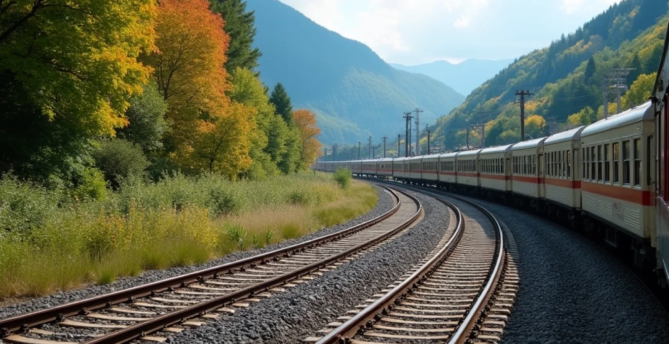
Japan’s countryside offers some of the world’s most spectacular railway journeys, where traditional villages nestled in mountain valleys and pristine coastal landscapes unfold beyond train windows. The country’s extensive rail network provides unparalleled access to remote regions that showcase Japan’s natural beauty and cultural heritage. From mist-shrouded mountain passes in Fukushima to volcanic landscapes in Kyushu, scenic railway routes traverse diverse ecosystems and seasonal panoramas that transform throughout the year.
Planning a comprehensive countryside rail journey requires understanding Japan’s complex ticketing systems, seasonal variations, and regional connectivity patterns. The strategic selection of rail passes, combined with careful timing and route optimisation, enables travellers to experience Japan’s rural heartlands efficiently and cost-effectively. Modern booking platforms and timetable applications have simplified the planning process, though navigating local transportation integration points requires additional consideration for seamless countryside exploration.
Essential JR pass types and regional rail network coverage for countryside exploration
Understanding Japan’s rail pass ecosystem forms the foundation of effective countryside journey planning. The Japan Rail Pass system encompasses nationwide and regional options, each designed to serve different travel patterns and geographical coverage areas. Strategic pass selection significantly impacts both travel costs and accessibility to remote scenic routes, making informed decision-making crucial for countryside exploration.
JR pass nationwide vs regional pass Cost-Benefit analysis for rural routes
The nationwide JR Pass provides comprehensive coverage across all JR lines, including most Shinkansen services and rural branch lines that penetrate deep into countryside regions. At ¥29,650 for seven days or ¥47,250 for fourteen days, the nationwide pass offers exceptional value for extensive countryside exploration spanning multiple prefectures. Rural journeys often require combinations of express trains and local services, where the unlimited travel flexibility proves invaluable for spontaneous route adjustments and extended stays in remote locations.
Regional passes target specific geographical areas with concentrated scenic attractions, typically priced between ¥15,000 and ¥25,000 for five to seven days. These passes excel for focused countryside exploration within defined regions, offering deeper penetration into local rail networks that nationwide passes may not emphasise. Regional pass coverage often includes non-JR lines and connecting bus services essential for accessing remote trailheads, mountain villages, and coastal viewpoints beyond primary rail corridors.
JR east pass nagano niigata area coverage for alpine scenic corridors
The JR East Pass Nagano Niigata Area encompasses Japan’s most dramatic alpine corridors, including access to the Japanese Alps through scenic mountain railways. This regional pass covers the Resort View Furusato panoramic train service along the Oito Line, where floor-to-ceiling windows frame views of the Northern Alps and pristine mountain lakes. The pass includes coverage of the Joetsu Shinkansen to Niigata, connecting coastal and mountain regions through diverse topographical zones.
Seasonal variations significantly impact the alpine corridor experience, with spring offering cherry blossoms at lower elevations while higher passes remain snow-covered. Summer provides optimal hiking conditions and clear mountain visibility, whilst autumn delivers spectacular foliage displays across elevation gradients. Winter transforms these corridors into snow country wonderlands, with specialised snow viewing trains and winter sports access adding unique seasonal appeal to countryside rail journeys.
JR west kansai wide area pass access to kumano kodo and san’in coast lines
The JR West Kansai Wide Area Pass unlocks access to the spiritual heartlands of the Kii Peninsula, including rail connections to Kumano Kodo pilgrimage routes and pristine coastal corridors along the San’in Coast. This pass covers the Kuroshio limited express service, which winds through mountainous terrain to reach sacred sites and traditional hot spring villages tucked away in forested valleys. The coverage extends to rural stations serving UNESCO World Heritage pilgrimage trails, where ancient spiritual practices continue in remote mountain settings.
San’in Coast coverage provides access to Japan’s most dramatic sea cliffs and traditional fishing communities along the Japan Sea coastline. The pass includes services on the Kinosaki Onsen line, connecting travellers to historic hot spring towns where traditional ryokan hospitality thrives alongside therapeutic natural springs. Coastal route timing becomes crucial during winter months when dramatic wave action and seasonal weather patterns create spectacular viewing conditions along exposed cliff sections.
Hokkaido rail pass integration with kushiro wetlands and furano lavender routes
Hokkaido’s vast wilderness areas require dedicated regional pass coverage to access remote wetland preserves and agricultural landscapes that define Japan’s northernmost prefecture. The Hokkaido Rail Pass provides comprehensive coverage of the Senmo Line through Kushiro Wetlands, where red-crowned cranes perform elaborate courtship displays amidst pristine marshland ecosystems. This route offers unparalleled wildlife viewing opportunities during early morning hours when mist rises from wetland waters and wildlife activity peaks.
Furano’s lavender fields represent Hokkaido’s agricultural heritage, accessible via the Furano Line through rolling farmland that transforms seasonally from snow-covered plains to vibrant flower carpets. The pass coverage includes connections to the Norokko sightseeing trains that operate during peak lavender season, featuring open-air carriages designed specifically for countryside photography and immersive landscape viewing. Agricultural timing determines optimal viewing periods, with lavender blooming from mid-June through early August creating Purple corridors across Hokkaido’s central plains.
Kyushu rail pass connectivity to Aso-Kuju national park and takachiho gorge
Kyushu’s volcanic landscapes require specialised rail access through mountainous terrain where dramatic geological features create unique countryside viewing experiences. The Kyushu Rail Pass covers the Aso Boy! themed train service through Aso-Kuju National Park, where active volcanic peaks frame pastoral grazing lands and traditional farming communities. This route traverses caldera floors where ancient volcanic activity shaped distinctive geographical features visible from elevated railway viaducts.
Takachiho Gorge access requires careful coordination between rail services and local transportation networks, as the pass covers connections to bus services that complete the journey to this mythologically significant landscape. The gorge’s dramatic basalt columns and cascading waterfalls represent volcanic forces that shaped Kyushu’s interior, whilst surrounding countryside maintains traditional agricultural practices adapted to volcanic soils. Geological timing affects visibility conditions, with clear weather providing optimal viewing of volcanic features and seasonal water flow variations creating different aesthetic experiences throughout the year.
Strategic route planning through japan’s premier scenic railway corridors
Japan’s premier scenic railway corridors require sophisticated route planning to maximise landscape viewing opportunities whilst coordinating complex timetable schedules and seasonal accessibility patterns. These corridors traverse diverse ecological zones where elevation changes, weather patterns, and seasonal phenomena create dynamic viewing conditions that vary dramatically throughout the year. Understanding corridor characteristics enables travellers to optimise timing and positioning for enhanced countryside experiences.
Strategic corridor selection balances travel efficiency with landscape immersion, requiring careful consideration of timetable frequencies, weather dependencies, and photographic opportunities across seasonal cycles.
Tadami line’s fukushima prefecture bridge crossings and seasonal foliage windows
The Tadami Line through Fukushima Prefecture represents Japan’s most photographically celebrated railway corridor, where iconic bridge crossings frame pristine river valleys surrounded by undisturbed forest ecosystems. The First Tadami River Bridge crossing provides the route’s signature viewpoint, where elevated railway infrastructure creates dramatic perspectives over ancient forest canopies that transform spectacularly during autumn foliage seasons. This corridor operates with limited daily services, requiring precise timing coordination for optimal viewing conditions.
Seasonal foliage windows typically occur from mid-October through early November, when deciduous forests display peak colour intensity across elevation gradients visible from train windows. Spring offers contrasting beauty with mountain cherry blossoms and fresh green foliage, whilst winter creates monochromatic landscapes where snow-covered conifers provide stark beauty against river corridors. Weather dependency significantly affects visibility, with clear conditions essential for capturing the corridor’s full scenic impact and photographic potential.
The route’s infrastructure limitations create unique viewing opportunities where single-track operations and manual signal systems maintain historical railway operating patterns. Vintage train operations during peak seasons enhance the nostalgic atmosphere, though limited capacity requires advance booking for guaranteed travel during optimal foliage periods. Station facilities remain minimal throughout the corridor, emphasising the remote wilderness character that defines this exceptional scenic railway experience.
Gono line coastal trajectory along akita’s Shirakami-Sanchi UNESCO wilderness
The Gono Line’s coastal trajectory along Akita Prefecture provides unparalleled access to Shirakami-Sanchi UNESCO World Heritage wilderness areas, where ancient beech forests meet dramatic Japan Sea coastlines. This route operates along exposed cliff sections where railway infrastructure hugs coastal contours, providing passengers with direct views of wave action against rocky shores and distant mountain silhouettes. The corridor’s exposure to maritime weather creates dynamic viewing conditions that change rapidly with wind patterns and seasonal storm systems.
UNESCO wilderness designation ensures pristine forest ecosystems remain undisturbed along inland sections, where ancient beech groves represent some of Japan’s last remaining old-growth deciduous forests. The railway provides the primary access method for viewing these protected ecosystems, as wilderness regulations restrict alternative transportation development within designated areas. Seasonal transitions create dramatic landscape transformations, from winter storm watching opportunities to summer forest canopy viewing and autumn foliage displays across protected wilderness boundaries.
Resort Shirakami themed train services enhance the wilderness experience through specialised viewing carriages and onboard interpretation programmes that highlight ecological significance and conservation achievements. These services operate seasonally with advance reservations required, though regular local trains provide year-round access for independent exploration. Coastal sections offer wildlife viewing opportunities including seabird colonies and marine mammal sightings, particularly during migration seasons when protected waters attract diverse species.
Hanawa line’s remote mountain passage through iwate’s traditional villages
The Hanawa Line penetrates deep into Iwate Prefecture’s mountain interior, connecting remote traditional villages that maintain historical agricultural practices and architectural heritage largely unchanged by modern development. This corridor traverses elevation zones from coastal plains through forested mountains to interior valleys, where traditional farming communities practice sustainable agriculture adapted to challenging mountain conditions. The route’s limited daily services reflect the sparse population density whilst providing essential connectivity for rural communities.
Traditional villages along the route showcase historical Japanese rural architecture, including thatched-roof farmhouses and traditional craft workshops that utilise local natural resources. The railway provides access to cultural experiences unavailable in urban areas, where visitors can observe traditional textile production, woodworking techniques, and sustainable farming methods preserved through generations. Cultural timing affects village activities, with seasonal festivals, agricultural cycles, and craft production schedules creating varied opportunities for cultural immersion throughout the year.
Mountain passage sections offer pristine wilderness viewing where undeveloped forest corridors provide habitat for native wildlife species rarely observed in more accessible regions. The route’s engineering challenges required innovative solutions for steep gradients and unstable geology, creating unique viewing perspectives from elevated bridge crossings and tunnel portals. Winter operations demonstrate remarkable reliability despite challenging mountain conditions, though seasonal accessibility variations affect some connecting services and village accessibility patterns.
Hisatsu line’s kirishima volcanic landscape navigation in southern kyushu
The Hisatsu Line through southern Kyushu navigates active volcanic landscapes where ongoing geological processes create dynamic terrain features visible from elevated railway viaducts and mountain crossing points. This corridor traverses the Kirishima volcanic complex, where multiple active peaks generate steam emissions and occasional ash falls that demonstrate ongoing volcanic activity. The route provides unique opportunities to observe volcanic landscapes from safe distances whilst maintaining reliable transportation despite challenging geological conditions.
Switchback operations at strategic locations enable trains to navigate steep volcanic terrain where direct routing would be impossible, creating multiple viewing angles of volcanic features and surrounding countryside. These engineering solutions provide passengers with extended viewing opportunities whilst demonstrating historical railway construction techniques adapted to challenging topographical conditions. Volcanic activity occasionally affects operations, though monitoring systems ensure passenger safety whilst maintaining access to these spectacular geological environments.
The corridor connects hot spring resort communities that utilise geothermal resources generated by volcanic activity, where traditional onsen culture thrives alongside modern therapeutic facilities. Rural stations provide access to hiking trails that explore volcanic features safely, including crater lakes, fumaroles, and historic lava flow areas. Seasonal variations affect volcanic visibility and activity levels, with clear weather providing optimal viewing conditions for distant volcanic peaks and steam emission patterns that characterise this dynamic landscape.
Hyperdia timetable optimisation and reserved seat booking strategies
Modern timetable optimisation through digital platforms revolutionises countryside railway journey planning, enabling precise coordination of complex route combinations and seasonal service variations. Hyperdia and similar applications provide comprehensive scheduling data that accounts for regional service frequencies, weather-dependent operations, and seasonal timetable modifications that significantly impact countryside accessibility. Advanced booking strategies ensure seat availability on limited-capacity scenic services whilst maintaining flexibility for weather-dependent route adjustments.
Digital integration streamlines the complex process of coordinating multiple rail companies, service types, and regional connections required for comprehensive countryside exploration. Modern platforms incorporate real-time service updates, alternative routing suggestions, and integration with accommodation and activity bookings that support extended rural stays. Understanding platform capabilities and limitations enables travellers to develop sophisticated itineraries that maximise countryside exposure whilst minimising logistical complications.
Reserved seat strategies become particularly crucial for scenic train services with limited daily operations and seasonal capacity constraints. Popular routes like the Tadami Line and Resort Shirakami services require advance booking during peak periods, whilst flexible ticketing options accommodate weather-dependent changes common in mountain and coastal corridors. Booking timing considerations include seasonal demand patterns, weather forecast reliability, and alternative route availability when primary services face cancellations or capacity limitations.
Integration with accommodation booking systems enables coordinated planning where countryside railway access aligns with rural lodging availability and local activity scheduling. Remote areas often feature limited accommodation options that require advance reservation, particularly during peak viewing seasons when demand exceeds capacity. Comprehensive planning tools that integrate transportation, accommodation, and activity bookings ensure seamless countryside experiences whilst maintaining flexibility for spontaneous discoveries and weather-dependent modifications.
Seasonal photography opportunities and weather pattern considerations
Seasonal photography opportunities across Japan’s countryside railways follow predictable patterns that enable strategic timing for optimal landscape capture and weather condition planning. Understanding regional climate variations, elevation effects, and seasonal phenomena timing ensures travellers experience countryside railways during peak aesthetic periods whilst avoiding weather conditions that limit visibility or accessibility. Each season offers distinct photographic opportunities that require different planning approaches and equipment considerations.
Spring photography focuses on cherry blossom progression across elevation gradients, where mountain railways provide access to extended blooming seasons as flowers appear progressively up mountainsides. The sakura front moves northward and upward in elevation, creating opportunities to follow peak blooming conditions across multiple regions and railway corridors. Early spring also offers dramatic contrast between snow-covered peaks and valley floor blooming, whilst late spring provides fresh green foliage that creates vibrant landscape compositions.
Seasonal timing windows require precise coordination between weather patterns, natural phenomena cycles, and railway scheduling to capture peak countryside beauty during optimal conditions.
Autumn foliage photography demands understanding of elevation-dependent colour progression, where mountainous railway routes provide access to extended viewing seasons as colours progress downward from higher elevations. Peak timing varies by region and elevation, typically occurring from late September in northern mountains through mid-November in lower elevations. Weather stability during autumn affects foliage longevity and photographic conditions, with typhoon seasons potentially affecting accessibility and viewing quality during peak colour periods.
Winter photography opportunities focus on snow-covered landscapes and specialised seasonal phenomena like drift ice viewing along northern coastal railways. Clear winter weather provides optimal mountain visibility and snow landscape contrast, whilst stormy conditions create dramatic coastal viewing opportunities along exposed railway sections. Weather pattern understanding becomes crucial for winter planning, as sudden weather changes can affect both accessibility and photographic conditions in mountain and coastal corridors.
Summer photography emphasises agricultural landscapes, mountain hiking access, and extended daylight hours that enable morning and evening golden hour photography along countryside routes. Highland areas provide relief from lowland heat and humidity whilst offering unique alpine landscape access through scenic mountain railways. Weather predictability typically improves during summer months, enabling more reliable planning for extended countryside photography expeditions and multi-day rural exploration programmes.
Rural station infrastructure and local transportation integration points
Rural station infrastructure varies significantly across Japan’s countryside, from unstaffed platforms serving remote villages to regional hubs that coordinate multiple transportation modes for comprehensive rural access. Understanding infrastructure limitations and capabilities enables travellers to plan appropriate connections, equipment requirements, and timing considerations essential for successful countryside exploration. Many rural stations feature minimal facilities whilst serving as crucial access points to wilderness areas and traditional communities.
Local transportation integration becomes essential where railway access provides partial connectivity to countryside destinations, requiring coordination with bus services, taxi systems, or rental bicycle networks to reach final destinations. Rural bus schedules often align with limited train services, creating coordinated timetables that enable day-trip access to remote locations. However, service frequencies typically reflect local population density, requiring careful planning to avoi
d being stranded in remote areas with limited return transportation options.
Station amenities vary dramatically from major regional hubs with full service facilities to unmanned platforms where passengers must signal trains manually to request stops. Large stations typically feature multilingual signage, tourist information centres, and equipment rental services including bicycles and hiking gear essential for countryside exploration. Smaller stations may lack basic facilities like restrooms or weather shelter, requiring travellers to prepare accordingly with appropriate supplies and contingency planning.
Infrastructure assessment before arrival enables appropriate preparation for rural station conditions and local transportation availability. Many remote stations serve as trailheads for hiking routes or cycling paths that provide deeper countryside access beyond railway corridors. Station parking facilities often accommodate rental cars for visitors requiring greater mobility to explore dispersed rural attractions, whilst some stations feature dedicated spaces for bicycle storage during multi-modal countryside adventures.
Digital integration increasingly supports rural station operations through mobile applications that provide real-time arrival information, local transportation schedules, and destination guidance for onward connections. QR code systems at unmanned stations enable ticket purchases and journey planning without staffed assistance, whilst GPS integration helps travellers navigate from stations to nearby attractions or accommodation. However, reliable mobile connectivity cannot be guaranteed in remote areas, making offline preparation and backup navigation methods essential for successful countryside exploration.
Local transportation coordination requires understanding of regional patterns where bus services may operate seasonally or on limited schedules that align with school terms or agricultural cycles. Tourist-oriented shuttle services often operate during peak seasons to popular destinations like hiking trailheads or scenic viewpoints, whilst year-round local services primarily serve resident populations with scheduling that reflects daily commuting patterns rather than tourist convenience.
Rural transportation networks often rely on community-based services and volunteer drivers during off-peak periods, requiring flexibility and patience for travellers seeking authentic countryside experiences beyond major tourist corridors.
Bicycle rental availability at rural stations provides sustainable transportation for countryside exploration whilst reducing reliance on infrequent public transportation services. Electric bicycle options expand accessibility for hilly terrain common in rural areas, whilst traditional bicycles offer quiet countryside immersion through agricultural valleys and forest paths. Station-based rental systems typically require advance booking during peak seasons, though walk-in availability improves during quieter periods when demand decreases.
Weather shelter considerations become crucial at exposed rural stations where platform facilities may be minimal during adverse conditions. Mountain stations particularly require preparation for rapidly changing weather patterns, whilst coastal stations face exposure to maritime weather systems that can affect both comfort and safety. Seasonal preparation includes appropriate clothing for extended waiting periods and potential service delays common in challenging weather conditions that affect rural railway operations.
Taxi services in rural areas often require advance booking rather than on-demand availability common in urban areas, with limited vehicles serving large geographical regions. Local taxi operators frequently offer touring services that combine transportation with regional knowledge, providing guided countryside experiences that complement railway travel. Pricing structures typically reflect distance and time rather than urban metered systems, requiring negotiation or advance agreement for extended countryside exploration tours.
Language considerations affect rural station navigation where English signage may be limited or absent entirely, requiring basic Japanese phrases or translation applications for effective communication. Station staff, where present, may have limited English capability though universally demonstrate helpfulness and patience with foreign visitors. Visual navigation aids including maps, photographs, and gesture communication prove valuable for overcoming language barriers in rural transportation planning.
Accommodation coordination with rural station access requires careful timing alignment between train arrivals and accommodation check-in procedures, particularly for traditional ryokan establishments that may have specific arrival windows. Remote accommodations often provide pickup services from nearby stations, though advance arrangement becomes essential as these services operate on fixed schedules rather than on-demand availability. Station proximity to accommodation varies significantly, from walking distance to requiring substantial ground transportation that may not operate during evening hours when many trains arrive at rural destinations.