Nestled in the Atlantic waters off France’s Charente-Maritime coast, Île de Ré emerges as one of Europe’s most distinctive island destinations. This slender strip of land, measuring approximately 30 kilometres in length and just 5 kilometres at its widest point, captivates visitors with its unique blend of maritime heritage , architectural treasures, and sustainable tourism practices. The island’s transformation from a collection of separate islets into today’s unified landmass tells a remarkable story of natural evolution and human ingenuity, making it a fascinating case study in coastal geography and cultural preservation.
What distinguishes Île de Ré from other French coastal destinations lies not merely in its pristine beaches or charming villages, but in its commitment to environmental conservation and traditional craftsmanship. From the ancient art of salt harvesting to the engineering marvel of the Pont de l’Île de Ré, every aspect of island life reflects a careful balance between progress and preservation. The island’s designation as a UNESCO World Heritage site for its military architecture speaks to its historical significance, while its modern cycling infrastructure demonstrates forward-thinking sustainable tourism approaches.
Geographical marvel: île de ré’s unique atlantic archipelago position
Île de Ré occupies a strategically significant position within the Pertuis Charentais, a complex marine environment where the Atlantic Ocean meets the French mainland. This location places the island at the heart of one of Europe’s most important tidal ecosystems , where the interplay between oceanic currents, sediment deposits, and human intervention has shaped a landscape unlike any other. The island’s geological foundation consists primarily of Jurassic limestone, which contributes to the characteristic white appearance of traditional buildings and provides the mineral-rich substrate essential for the famous salt marshes.
The archipelago’s evolution from four separate islets into a single landmass represents thousands of years of natural sedimentation processes, augmented by human engineering efforts. These original islets – Ars, Loix, Ré, and Rivedoux – remain identifiable today through subtle elevation changes and distinct cultural characteristics within their respective communities. The spaces between these former islands have been transformed into productive salt marshes, creating an intricate network of waterways that serve both ecological and economic functions.
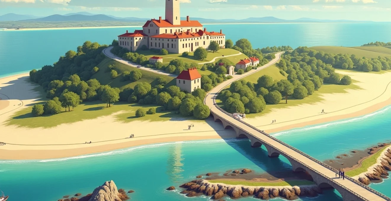
Pont de l’île de ré: engineering excellence connecting mainland Charente-Maritime
The construction of the Pont de l’Île de Ré in 1988 marked a pivotal moment in the island’s accessibility and economic development. This 2.9-kilometre cable-stayed bridge represents one of France’s most significant coastal engineering achievements, designed to withstand the harsh Atlantic conditions while minimising environmental impact on the surrounding marine ecosystem. The bridge’s 42-metre clearance allows maritime traffic to pass underneath, maintaining the vital shipping lanes that connect La Rochelle to international ports.
Engineering specifications for the bridge incorporate advanced materials and design principles to combat salt corrosion and extreme weather conditions. The structure features a central span of 201 metres supported by twin towers rising 88 metres above sea level, creating an elegant silhouette that has become synonymous with the island’s modern identity. Traffic management systems on the bridge include variable toll pricing designed to encourage sustainable transport choices and reduce congestion during peak summer periods.
Salt marsh ecosystems and protected natura 2000 designation status
The salt marshes of Île de Ré encompass approximately 1,500 hectares of protected wetland habitat, earning designation under the European Union’s Natura 2000 network for their exceptional biodiversity value. These marshes support over 300 bird species throughout the year, including significant populations of migratory waders that utilise the area as a critical stopover point along the East Atlantic Flyway. The complex system of écluses (sluices) and channels that regulate water levels represents centuries of refined hydraulic engineering adapted to local tidal patterns.
Ecological monitoring within the marshes reveals remarkable biodiversity, with specialised plant communities adapted to varying salinity levels and periodic flooding. The presence of salicornia (samphire) and other halophytic vegetation creates unique microhabitats that support diverse invertebrate communities, forming the foundation of complex food webs. These ecosystems demonstrate remarkable resilience to climate change impacts, serving as natural buffers against storm surges and sea-level rise.
Pertuis d’antioche marine environment and tidal dynamics
The Pertuis d’Antioche, the marine channel separating Île de Ré from Île d’Oléron, creates one of France’s most dynamic tidal environments. With tidal ranges exceeding 6 metres during spring tides, these waters generate powerful currents that have shaped the island’s coastline over millennia. The interaction between Atlantic swells and these confined waters produces unique wave patterns that influence both marine ecosystems and human activities such as oyster cultivation and recreational sailing.
Oceanographic studies reveal complex current systems within the Pertuis d’Antioche that transport nutrients and sediments throughout the region. These currents support productive marine ecosystems while simultaneously challenging navigation and coastal management efforts. The semi-diurnal tidal cycle creates twice-daily opportunities for traditional fishing methods, particularly the use of carrelets (square fishing nets) that have been employed in these waters for over five centuries.
Microclimatic conditions created by gulf stream influence
Île de Ré benefits from a distinctive microclimate influenced by the Gulf Stream’s warming effect on Atlantic waters. This maritime influence moderates temperature extremes, creating conditions that support both Mediterranean and Atlantic plant species within a remarkably small geographic area. Average temperatures remain 2-3 degrees higher than mainland locations at similar latitudes, enabling the cultivation of early potatoes and grapes that achieve unique flavour profiles.
The island’s position relative to prevailing wind patterns creates distinct microclimatic zones, with the eastern areas experiencing greater protection from Atlantic storms while the western coastline faces the full force of oceanic weather systems. These variations have influenced settlement patterns and agricultural practices throughout the island’s history, with villages strategically positioned to maximise shelter while maintaining access to marine resources.
Architectural heritage: vauban fortifications and maritime defence systems
The architectural legacy of Île de Ré reflects centuries of strategic military importance and maritime commerce. The island’s position at the entrance to La Rochelle made it a crucial defensive outpost, leading to the development of sophisticated fortification systems that represent some of Europe’s finest examples of coastal military architecture . These structures demonstrate the evolution of defensive technology from medieval castles to early modern star forts, adapted to the unique challenges of island warfare and artillery development.
The integration of military and civilian architecture creates a distinctive urban landscape where defensive walls enclose thriving communities. This approach to fortified town planning reflects Renaissance theories about ideal city design, where security considerations balanced with commercial and residential needs. The preservation of these architectural ensembles provides insight into historical approaches to urban planning and community defence strategies.
Saint-martin-de-ré citadel: UNESCO world heritage military architecture
The citadel of Saint-Martin-de-Ré stands as the crowning achievement of Sébastien Le Prestre de Vauban’s fortification system, earning UNESCO World Heritage designation in 2008 as part of the “Fortifications of Vauban” series. Construction began in 1681 following designs that integrated the latest developments in military engineering with the specific geographical challenges of island defence. The star-shaped fortification incorporates advanced geometric principles that maximise defensive firepower while minimising blind spots and structural vulnerabilities.
Architectural details within the citadel demonstrate remarkable craftsmanship in local limestone construction, with precisely cut stones forming complex curved walls and underground passages. The fortress includes sophisticated water management systems, ammunition storage facilities, and accommodation for garrison troops, all designed to withstand extended sieges. The integration of the citadel with the existing town created a unique urban environment where military function and civilian life coexisted within the same defensive perimeter.
Fort la prée and coastal battery strategic positioning
Fort La Prée, constructed in 1625 under Louis XIII, represents an earlier phase of French coastal fortification that predates Vauban’s systematic approach. The fort’s strategic positioning on the island’s eastern shore provided control over the primary shipping channel to La Rochelle, demonstrating the sophisticated understanding of maritime strategy that influenced French naval policy. Unlike later fortifications, Fort La Prée retains characteristics of Renaissance military architecture, with thick walls designed to resist cannon fire rather than accommodate artillery positions.
The evolution of Fort La Prée through successive military periods illustrates changing approaches to coastal defence technology. Modifications during the 18th and 19th centuries added artillery positions optimised for longer-range cannon, while 20th-century adaptations included concrete bunkers and anti-aircraft installations. The fort’s varied architectural elements create a comprehensive museum of military engineering spanning four centuries of technological development.
Traditional charentaise architecture with distinctive White-Washed facades
The distinctive white-washed buildings of Île de Ré represent a unique architectural tradition adapted to maritime environmental conditions and local building materials. Traditional construction techniques utilise local limestone blocks bonded with mortar containing crushed oyster shells, creating walls that resist salt corrosion while maintaining thermal efficiency. The characteristic white lime wash serves both practical and aesthetic functions, reflecting solar radiation while providing protection against moisture penetration.
Architectural features such as the distinctive green shutters and terracotta roof tiles reflect influences from both Atlantic and Mediterranean building traditions, creating a synthesis unique to the Charente-Maritime region. Window proportions and door placements follow traditional patterns that optimise natural ventilation while providing protection from Atlantic storms. The preservation of these architectural characteristics through strict planning controls maintains the island’s visual coherence while accommodating modern building standards and comfort requirements.
Historic lighthouse infrastructure: phare des baleines engineering
The Phare des Baleines lighthouse complex represents two centuries of lighthouse technology development, with structures dating from 1682 and 1854 providing comparative examples of evolving maritime safety approaches. The modern lighthouse rises 57 metres above sea level, utilising a rotating Fresnel lens system that produces a distinctive light pattern visible up to 50 kilometres at sea. The engineering challenges overcome during construction included foundation work in unstable coastal soils and the transportation of massive lens components to the remote western tip of the island.
Technical specifications for the lighthouse incorporate advanced materials and precision engineering that demonstrate 19th-century achievements in optical technology and mechanical engineering. The lighthouse mechanism includes clockwork systems that required daily winding to maintain rotation, automated fog signals, and weather monitoring equipment. The preservation of these technical systems provides insight into the sophisticated approaches to maritime safety that protected shipping in one of Europe’s most challenging coastal environments.
Artisanal salt production: traditional paludier techniques and fleur de sel harvesting
The ancient craft of salt production on Île de Ré represents one of Europe’s last remaining examples of traditional paludier techniques, where skilled artisans harvest sea salt using methods unchanged for over a thousand years. This labour-intensive process requires intimate knowledge of tidal patterns, weather conditions, and the precise timing necessary to achieve optimal salt crystal formation. The island’s 400 hectares of active salt marshes support approximately 100 salt producers who maintain the delicate balance between productivity and environmental stewardship that characterises this sustainable industry.
The economic significance of salt production extends far beyond its direct commercial value, supporting a complex ecosystem of related activities including tourism, gastronomy, and cultural preservation. The Protected Geographical Indication (PGI) status awarded to Île de Ré sea salt in 2023 recognises the unique terroir and traditional methods that produce salt with distinctive mineral content and flavour characteristics. This certification protects both the economic interests of local producers and the cultural heritage associated with traditional salt harvesting techniques.
The fleur de sel of Île de Ré represents the pinnacle of artisanal salt production, where perfect climatic conditions combine with centuries of refined harvesting techniques to create crystals of exceptional purity and flavour complexity.
The technical aspects of salt production involve sophisticated understanding of water management, crystal formation, and quality control that requires years of apprenticeship to master. Œillets (harvesting ponds) must be maintained at precise depths and salinity levels, with daily adjustments based on weather conditions, evaporation rates, and tidal cycles. The harvesting of fleur de sel, the delicate surface crystals that form under specific atmospheric conditions, demands particular skill and timing that distinguishes master paludiers from casual practitioners.
Environmental benefits of traditional salt production include habitat creation for specialised wildlife, natural water filtration, and carbon sequestration within marsh ecosystems. The extensive network of channels and ponds creates diverse microhabitats that support over 150 bird species, making salt marshes among the most biologically productive ecosystems in temperate regions. The maintenance of these artificial wetlands requires continuous management that demonstrates successful integration of economic activity with environmental conservation.
Viticultural excellence: cognac appellation terroir and maritime wine production
Île de Ré’s viticultural heritage dates to the 12th century when Cistercian monks established the first vineyards, recognising the island’s unique potential for grape cultivation. The maritime terroir combines limestone soils with Atlantic influence to produce wines with distinctive mineral characteristics and exceptional aging potential. Modern viticultural practices on the island’s 600 hectares of vineyards integrate traditional knowledge with contemporary sustainable farming techniques, resulting in wines that express the unique environmental conditions of this Atlantic island location.
The island’s inclusion within the Cognac appellation demonstrates the quality potential of its viticultural terroir, with local producers contributing to one of France’s most prestigious spirit designations. The maritime influence moderates temperature extremes while providing consistent moisture levels that support healthy vine development throughout the growing season. Harvest timing on Île de Ré typically occurs 10-14 days earlier than mainland vineyards, reflecting the warming influence of surrounding waters and the early ripening characteristics of island-grown grapes.
Wine production statistics reveal the island’s growing reputation within French viticultural circles, with annual production exceeding 3 million bottles across white, rosé, red, and sparkling wine categories. The cooperative cellar model adopted by most island producers enables small-scale growers to access modern winemaking facilities and marketing networks while maintaining individual vineyard management approaches. This collaborative approach has proven particularly effective in developing export markets and establishing quality recognition for Île de Ré wines beyond traditional regional boundaries.
Sustainable viticulture practices implemented across the island include organic certification for over 40% of vineyard area, integrated pest management systems, and water conservation techniques adapted to the constraints of island agriculture. Cover crop management between vine rows provides soil protection while supporting beneficial insect populations that contribute to natural pest control. The adoption of precision viticulture technologies enables producers to optimise irrigation and fertilisation while minimising environmental impact on surrounding salt marsh ecosystems .
Cycling infrastructure: piste cyclable network and sustainable tourism model
Île de Ré has established itself as a global exemplar of sustainable tourism through its comprehensive cycling infrastructure that prioritises non-motorised transport throughout the island. The systematic development of dedicated cycling paths began in the 1970s and now encompasses over 100 kilometres of segregated routes that connect every village, beach, and major attraction. This infrastructure represents a significant financial investment in sustainable tourism that has transformed visitor behaviour while preserving the island’s fragile environmental and cultural resources.
The success of the cycling network demonstrates how thoughtful transportation planning can enhance rather than compromise the visitor experience. Journey times by bicycle often prove faster than automotive transport, particularly during peak summer periods when traffic restrictions and limited parking create significant delays for car users. The flat terrain and prevailing wind patterns create ideal conditions for cycling, making the island accessible to riders of all ages and fitness levels.
100-kilometre dedicated cycling path system design
The engineering design of Île de Ré’s cycling infrastructure incorporates best practices from Dutch and Danish cycling planning, adapted to the specific challenges of coastal environments and seasonal tourism patterns. Path construction utilises materials selected for durability under salt exposure while providing comfortable riding surfaces for the diverse range of bicycle types used by visitors. Strategic placement of rest areas, water stations, and bicycle repair facilities ensures that the network supports both recreational cycling and practical transportation needs.
Technical specifications for path construction include advanced drainage systems that prevent flooding during high tides and storm events, while surface materials balance comfort with maintenance requirements. The integration of cycling infrastructure with existing road networks required careful attention to intersection design and traffic management, with priority systems that favour cyclists over automotive traffic in most situations. Signage
systems and route marking utilise internationally recognised symbols combined with local wayfinding information that helps visitors navigate efficiently while discovering points of interest along their journeys.
Bicycle-priority traffic management and car restriction zones
Traffic management policies throughout Île de Ré prioritise cycling infrastructure over automotive access, creating a unique transportation hierarchy that encourages sustainable mobility choices. Vehicle restrictions during peak summer months limit access to historic village centres, while comprehensive parking management systems direct cars to peripheral areas connected by cycling paths. These policies have reduced traffic congestion by over 60% during peak periods while improving air quality and noise levels throughout residential areas.
The implementation of bicycle-priority traffic signals and dedicated crossing facilities ensures safe interaction between cycling and vehicular traffic at key intersections. Advanced traffic management technologies monitor cycling volumes and adjust signal timing to minimise delays for bicycle users, particularly during morning and evening commuter periods when local residents rely on cycling for daily transportation. Speed reduction measures in shared areas create comfortable environments for cyclists while maintaining essential vehicle access for residents and service providers.
Enforcement mechanisms support the bicycle-priority approach through automated monitoring systems and targeted education programmes for visiting drivers. Clear signage in multiple languages communicates traffic regulations and cycling etiquette, while visitor information centres provide comprehensive guidance on sustainable transportation options. The success of these measures demonstrates how small-scale destinations can effectively manage tourism impacts while enhancing the visitor experience through thoughtful transportation planning.
Eurovelo 1 atlantic coast route integration
Île de Ré’s cycling infrastructure forms a crucial component of the EuroVelo 1 Atlantic Coast Route, connecting the island to an international network of long-distance cycling routes that spans from Norway to Portugal. This integration positions the island as a significant destination for cycle tourism enthusiasts undertaking extended European cycling adventures. The connection to the mainland via the bridge creates seamless access for long-distance cyclists while providing opportunities for shorter excursions that showcase the island’s unique attractions.
Technical standards for EuroVelo route integration include consistent signage, surface quality, and safety features that meet international cycling infrastructure guidelines. The island’s flat terrain and comprehensive amenities make it an ideal rest stop for long-distance cyclists, with specialised accommodation and services catering to touring cyclists’ specific needs. Partnership agreements with regional tourism organisations promote the island as a highlight destination along the Atlantic Coast Route, generating sustainable tourism revenue while supporting environmental conservation goals.
Route planning resources and digital navigation tools provide detailed information about island attractions, accommodation options, and cycling services specifically designed for international visitors. The integration with broader European cycling networks demonstrates how local infrastructure investments can achieve regional and international significance while supporting sustainable tourism development. This approach creates economic benefits that extend far beyond traditional tourism seasons, attracting dedicated cycling enthusiasts throughout the year.
Gastronomic specialities: oyster cultivation and regional culinary traditions
The culinary landscape of Île de Ré reflects centuries of maritime traditions combined with innovative approaches to local food production that showcase the island’s unique terroir. The convergence of Atlantic waters, protected bays, and traditional farming techniques creates ideal conditions for producing exceptional seafood, early vegetables, and artisanal products that define the island’s gastronomic identity. Local chefs and producers collaborate to develop cuisine that celebrates these distinctive ingredients while maintaining authentic preparation methods passed down through generations of island families.
The island’s gastronomic reputation extends throughout France and internationally, with restaurants earning recognition for their innovative use of local ingredients and commitment to seasonal cooking principles. The Protected Designation of Origin status for various island products ensures quality standards while protecting traditional production methods from commercial pressure. This approach supports local producers while maintaining the authentic flavour profiles that distinguish Île de Ré cuisine from other coastal French regions.
Marennes-oléron oyster farming techniques in fier d’ars bay
The Fier d’Ars bay provides optimal conditions for oyster cultivation using traditional Marennes-Oléron techniques that produce oysters with distinctive flavour characteristics and exceptional quality. The bay’s unique hydrology combines freshwater inputs with Atlantic tidal flows, creating variable salinity levels that contribute to the complex mineral profiles of locally cultivated oysters. Over 60 oyster farms operate within the bay system, employing methods that balance productivity with environmental sustainability while maintaining the pristine water quality essential for premium oyster production.
Technical aspects of oyster farming include sophisticated understanding of tidal cycles, water temperature patterns, and nutrient availability that influence growth rates and flavour development. The traditional claire system utilises shallow clay-lined ponds where oysters undergo final maturation, developing the characteristic green tinge and refined taste that distinguishes Marennes-Oléron oysters. This finishing process requires precise management of water exchange rates and algae cultivation that supports the unique ecosystem necessary for premium oyster production.
Quality control measures throughout the cultivation process ensure that Île de Ré oysters meet the stringent standards required for Marennes-Oléron designation. Regular water quality monitoring, disease prevention protocols, and selective breeding programmes maintain healthy oyster populations while improving resistance to environmental stresses. The integration of traditional knowledge with modern aquaculture science demonstrates how ancestral techniques can adapt to contemporary challenges while preserving the essential characteristics that define artisanal oyster production.
Traditional fishing methods: carrelet fishing huts and techniques
The iconic carrelet fishing huts that dot the coastline of Île de Ré represent one of France’s most distinctive traditional fishing methods, employing large square nets operated from wooden platforms extending into tidal waters. These structures, some dating back over 500 years, demonstrate remarkable adaptation to local tidal patterns and seasonal fish migrations. The technique requires intimate knowledge of tide timing, fish behaviour, and weather conditions that experienced fishermen develop through decades of practice.
Construction techniques for carrelet installations utilise local materials and traditional joinery methods that withstand decades of salt exposure and tidal forces. The characteristic architectural form includes counterweighted lifting mechanisms that enable fishermen to operate large nets single-handedly while maintaining precise control over fishing depth and timing. Modern safety regulations and environmental protection measures have been integrated with traditional practices, ensuring that carrelet fishing continues while respecting marine conservation requirements.
The cultural significance of carrelet fishing extends beyond its economic contribution, serving as a symbol of island heritage and a tourist attraction that connects visitors with traditional maritime lifestyles. Educational programmes and guided tours provide opportunities for visitors to learn traditional fishing techniques while supporting local fishing families who maintain these historical practices. The preservation of carrelet fishing demonstrates successful integration of cultural heritage with sustainable fishing practices that benefit both local communities and marine ecosystems.
Local wine appellations: île de ré IGP classification standards
The Indication Géographique Protégée (IGP) classification for Île de Ré wines recognises the unique terroir characteristics that distinguish island production from mainland viticulture. The maritime climate creates growing conditions that produce wines with distinctive mineral content and acidity levels that reflect the influence of salt-laden Atlantic breezes. Soil composition featuring limestone bedrock with shell fragments contributes calcium and trace minerals that enhance wine complexity while providing excellent drainage necessary for quality grape production.
Viticultural regulations under the IGP classification specify permitted grape varieties, production methods, and quality standards that maintain consistency while allowing individual producers to express their unique interpretation of island terroir. White wine production focuses on traditional varieties such as Ugni Blanc and Sauvignon Blanc that thrive in maritime conditions, while red wine production utilises Cabernet Franc and Merlot adapted to the island’s specific growing conditions. The classification system protects both quality standards and the economic interests of local producers while promoting sustainable viticulture practices.
Wine tourism initiatives leverage the IGP classification to attract visitors interested in discovering unique French wine regions beyond traditional appellations. Cellar door experiences, vineyard tours, and food pairing events showcase island wines while educating visitors about the specific techniques required for successful maritime viticulture. The integration of wine tourism with broader island attractions creates comprehensive visitor experiences that support local producers while contributing to the island’s reputation as a premium gastronomic destination.
Artisanal cheese production: chabichou du poitou regional varieties
Artisanal cheese production on Île de Ré includes distinctive local variations of Chabichou du Poitou, a traditional goat cheese that benefits from the island’s unique grazing conditions and salt-influenced vegetation. Local goat herds graze on maritime pastures where salt-tolerant plants create distinctive flavour compounds that transfer to milk and subsequent cheese production. The island’s small-scale producers maintain traditional cheese-making techniques while adapting to the specific challenges of island agriculture and seasonal tourism demands.
Production methods for island Chabichou varieties incorporate traditional aging techniques using natural caves and controlled humidity environments that take advantage of the island’s stable coastal climate. The characteristic pyramid shape and natural rind development require precise timing and environmental control that master cheese makers develop through years of experience. Quality control measures ensure that island-produced cheeses maintain the standards required for regional designation while developing unique characteristics that reflect local terroir influences.
The integration of artisanal cheese production with agritourism initiatives provides additional income streams for local producers while educating visitors about traditional cheese-making techniques. Farm visits, tasting sessions, and educational workshops demonstrate the skill and knowledge required for successful goat cheese production in maritime environments. These activities support the economic viability of small-scale farming while preserving traditional knowledge and maintaining the cultural landscapes that define rural island heritage.